
Hoby & District Local History Society
“Using aerial LiDAR data to illuminate past landscapes” by Matthew Beamish
Matthew Beamish is a graduate of Cambridge University and has been working as an archaeologist in Leicestershire since 1990 is giving a talk on “Using aerial LiDAR data to illuminate past landscapes” at the Hoby & District Local History Society on Wednesday 17th November, 7.30pm, Hoby Village Hall (LE14 3DT). All are welcome; the price for non members is £2.00 (pay on door) or visit www.hobyanddistricthistory.co.uk
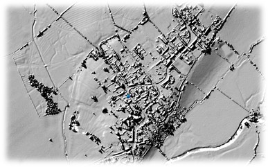
LiDAR makes the invisible visible. It has become one of the technological tools available to archaeologists. Matthew Beamish will explain how aerial LiDAR data can be used to illuminate past landscapes. Details of surface topography can be found where they cannot be seen with the naked eye, and in areas of woodland where traditional survey is not practical. The techniques of LIDAR processing and analysis will be illustrated with examples of different types of site from various periods.
Matthew Beamish is a graduate of Cambridge University and has been working as an archaeologist in Leicestershire since 1990. His archaeological expertise covers all prehistoric sites, including wetland preservation and wood technology. A particular highlight in recent years has been the analysis and experimental reconstruction of the first ever bark shield to have been found in the northern hemisphere. Technical expertise includes the development and implementation of database systems, site survey, the use of GIS systems, and the use of aerial LIDAR data. Matthew is the Membership Secretary for the Leicestershire Archaeological and Historical Society.
The Hoby & District Local History Society is a voluntary organisation. The Society brings together people from all walks of life who are interested in the local history of the Leicestershire villages of Hoby, Rotherby, Ragdale and Brooksby and the District around them. The society was founded in 2013.